- Página de inicio /
- Electrónica /
- GPS, Finders & Accessories /
- Sports & Handheld GPS /
- Handheld GPS Units /
- E1 GNSS Surveying System with Carbon Fiber Ro...
0 ratings


Nº de artículo:
87763566
E1 GNSS Surveying System with Carbon Fiber Rover Rod - Complete RTK Solution
Nº de artículo:
87763566
GTQ 14920
Price Details
Excluding Shipping & Custom charges ( Shipping and custom charges will be calculated on checkout )
*All items will import from Estados Unidos
0 ratings
Escribe una opinión
En stock
 Importado de la tienda USA
Secured transaction
Ubuy works hard to protect your security and privacy. Our advanced payment security system ensures confidentiality by encrypting your information during transmission using AES (Advanced Encryption Standards) and SSL (Secure Socket Layer) protocols. Your payment details are 100% secure as we do not share your payment details with third party sellers.
Our Top Logistics Partners


E1 achieves stable fixed solution rapidly, even in challenging environments like multipath, tree canopy, and city canyons.
Este paquete contiene 2 elementos


Fast
Shipping

Free
Return*

Secure Packaging

100% Original Products

PCI DSS Compliance

ISO 27001 Certified


What Stands Out
High Precision
The E1 GNSS Surveying System delivers exceptional accuracy and reliable positioning, essential for professional surveyors needing precise measurements in various environments.
Lightweight Design
Featuring a carbon fiber rover rod, this system is incredibly lightweight yet durable, enhancing portability and reducing fatigue during extended surveying tasks.
Complete Solution
This all-in-one RTK solution comes fully equipped, simplifying the setup process and ensuring users have all necessary components for efficient surveying right out of the box.
Detalles de producto
- 【Full-Constellation, Fixed in Seconds】E1 achieves stable fixed solution rapidly, even in challenging environments like multipath, tree canopy, and city canyons.E1 is equipped with a high-precision GNSS engine for simultaneously tracking GPS, BDS, GLONASS, Galileo, QZSS, IRNSS & SBAS.
- 【RTK Corrections Service/CORS Requirement】The E1 rover must connect to an RTK corrections service or a Continuously Operating Reference Station (CORS). You can purchase a third-party RTK service account or set up a GSM base station to get an RTK FIX solution. Check if your location is covered by CORS; you may need to buy local CORS services.
- 【Over 20hrs Operation】With optimized charging safety and internal battery design, E1 offers over 20 hours of continuous operation on a single charge, with fast charging support via Type-C port.
- 1 can compatible with base stations of other brands in both Radio and CORS mode. Support RTCM v3/CMR correction data transmission.
- 【60° Tilt, 5s Initialization】Equipped with a new generation IMU module, E1 initializes in just 5 seconds and allows tilt measurements up to 60°, ensuring ±2.5cm accuracy for the entire work.
| Additional Features | Tilt Measurement |
| Connectivity Technology | Bluetooth, USB, Wi-Fi |
| Map Types | Satellite |
| Battery Average Life | 20 Hours |
| Mounting Type | Handlebar Mount |
| Display Type | LED |
| Human Interface Input | Buttons |
| Compatible Devices | Smartphone, Tablet |
| Control Method | Touch |
| Are Batteries Included | Yes |
| Supported Satellite Navigation System | GPS |
| Brand | SingularXYZ |
| Model Name | E1 GNSS Surveying System |
| Built-In Media | Carbon Fiber Rover Rod |
| Manufacturer | SingularXYZ |
| Special Feature | Tilt Measurement |
| Map Type | Satellite |
| Included Components | Carbon Fiber Rover Rod |
| Battery Life | 20 Hours |
| Item Weight | 4.5 lbs (2.04 kg) |
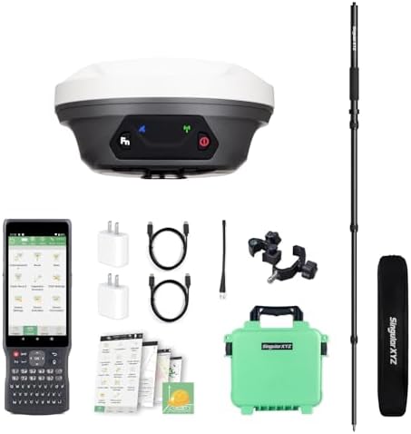
What's in the box
Carbon Fiber Rover Rod
Who Should Buy?

-
Survey Professionals
Ideal for land surveyors requiring high-precision data collection and real-time kinematic positioning for accurate measurements.
-
Construction Engineers
Beneficial for construction projects needing precise location data for site preparation, layout, and monitoring construction progress.
-
Geospatial Analysts
Perfect for geospatial analysis tasks where accurate positioning is crucial for mapping, modeling, and data collection.

-
Casual Users
Not suitable for hobbyists or casual users who require simple and cost-effective tools for basic location needs.
-
Small Projects
Less advantageous for small-scale projects where high precision and advanced features may not be necessary or cost-effective.
-
Budget-Conscious Buyers
May not meet the needs of users looking for budget-friendly options, given its advanced features and pricing.
DESCRIPCIÓN DEL PRODUCTO
¿Tienes alguna consulta? Chatea con nosotros
Preguntas y respuestas de los clientes
-
Pregunta:
What is the E1 GNSS Surveying System and its key features?
Respuesta: The E1 GNSS Surveying System is a comprehensive RTK solution designed for precise positioning and surveying applications. It features a high-accuracy GNSS receiver, a carbon fiber rover rod for lightweight portability, and robust software that enhances data collection. This system supports various GNSS signals, including GPS, GLONASS, and more, ensuring maximum accuracy and reliability. It is ideal for professionals in construction, engineering, and land surveying who require real-time data and location precision. -
Pregunta:
How does RTK (Real-Time Kinematic) work in the E1 GNSS Surveying System?
Respuesta: RTK, or Real-Time Kinematic positioning, uses a base station and a rover to achieve centimeter-level accuracy. The E1 GNSS Surveying System utilizes a base station that sends correction data to the rover, allowing for precise location tracking. This system is particularly beneficial for tasks that require high precision, such as topographic surveys, boundary delineation, and construction site assessments, ensuring your projects are accurately mapped without the need for extensive post-processing. -
Pregunta:
What advantages does the carbon fiber rover rod offer?
Respuesta: The carbon fiber rover rod provides several advantages including lightweight composition, durability, and stability. Its lightweight nature makes it easier to transport and maneuver during fieldwork, while its robust structure ensures it can withstand tough environmental conditions. This is particularly useful for surveyors working in varied terrains, where stability under different weather conditions is paramount for accurate surveying. Additionally, the carbon fiber material helps reduce fatigue during long working hours. -
Pregunta:
Can the E1 GNSS Surveying System be used for land surveying and construction?
Respuesta: Absolutely! The E1 GNSS Surveying System is specifically designed for land surveying and construction applications. Its high-precision positioning capabilities allow surveyors and construction professionals to conduct surveys, monitor site conditions, and create accurate maps and plans. Real-time data acquisition means that any discrepancies can be quickly addressed, facilitating smoother workflows and ensuring projects are done right the first time. -
Pregunta:
Is the E1 GNSS Surveying System compatible with other software?
Respuesta: Yes, the E1 GNSS Surveying System is compatible with a variety of surveying and mapping software. This compatibility allows users to integrate the system with existing projects and workflows seamlessly. Users can easily export data collected with the E1 system into software platforms for further analysis or reporting. This integration is essential for professionals in the surveying industry who rely on specific software tools for data processing and visualization. -
Pregunta:
What kind of battery life can I expect from the E1 GNSS Surveying System?
Respuesta: The E1 GNSS Surveying System typically offers extensive battery life, ensuring it can support long working hours without interruption. Its energy-efficient design allows users to conduct surveys over extended periods, which is crucial for fieldwork where access to power sources may be limited. This feature makes the system particularly advantageous for remote surveying projects or extended construction timelines. -
Pregunta:
Are there training resources available for using the E1 GNSS Surveying System?
Respuesta: Yes, countless training resources are available for users of the E1 GNSS Surveying System. These resources often include user manuals, online tutorials, and customer support services. Understanding how to operate the system effectively is essential for maximizing its benefits. Moreover, many manufacturers and suppliers offer training sessions or workshops that help users get hands-on experience with the system, thereby enhancing their surveying skills. -
Pregunta:
What is the accuracy level of the E1 GNSS Surveying System?
Respuesta: The E1 GNSS Surveying System offers high accuracy levels, often achieving precision within a few centimeters. This level of accuracy is critical for applications in surveying, construction, and mapping where small discrepancies can have significant consequences. With dual-frequency GNSS signals and RTK capability, users can expect consistent results that are reliable over various terrain types, making it suitable for both urban and rural projects. -
Pregunta:
Who can benefit from using the E1 GNSS Surveying System?
Respuesta: The E1 GNSS Surveying System benefits a wide range of professionals, including land surveyors, civil engineers, architects, and construction managers. Each group can leverage the system’s capabilities to enhance the accuracy of their work. For instance, land surveyors can perform precise boundary surveys, while engineers can utilize the data to assess site conditions. Additionally, urban planners can benefit from the accurate mapping features, ensuring effective project planning and execution. -
Pregunta:
Where can I buy the E1 GNSS Surveying System with Carbon Fiber Rover Rod in Guatemala?
Respuesta: You can buy the E1 GNSS Surveying System with Carbon Fiber Rover Rod at Ubuy, which offers a reliable shopping experience. Ubuy features a range of surveying equipment, ensuring you find the right tools for your needs. With a user-friendly interface and customer service support, Ubuy is an excellent choice for those looking to invest in high-quality surveying solutions.
SingularXYZ Handheld GPS Units Editorial Review
No se encontraron reseñas editoriales
Customer Reviews & Ratings
1 valoraciones de los clientes
-
5 estrella
100%
-
4 estrella
0%
-
3 estrella
0%
-
2 estrella
0%
-
1 estrella
0%
Revisar este producto
Comparte tus ideas con otros clientes
Platform Trust & Buyer Confidence

MT
Mohd
Verified buyer
“The product received very good packaging & safe…Thank You”
16 June 2026 · via Trustpilot
SJ
Shawati
Verified buyer
“Accurate delivery timing given”
16 June 2026 · via Trustpilot
YB
Youcef
Verified buyer
“Not madly expensive like I thought, and much quicker than promised.”
15 June 2026 · via Trustpilot
LM
Leila
Verified buyer
“Never dealt with Ubuy before, but everything worked out great. Seamless cross border purchasing and shipping. Thanks!”
6/7/2026 · via Trustpilot
KA
Kwame
Verified buyer
“The process was smooth, with clear communication and timelines. This was my 1st purchase and I am really impressed. I will definitely be coming back.”
12 June 2026 · via Trustpilot
Pago seguro
Global Delivery
Easy Returns
Genuine Products
Product Price History
Información importante
- Limitaciones: Para los productos enviados al extranjero, ten en cuenta que cualquier garantía del fabricante puede no ser válida; las opciones de servicio del fabricante pueden no estar disponibles; los manuales del producto, las instrucciones y las advertencias de seguridad pueden no estar en los idiomas del país de destino; los productos (y los materiales que los acompañan) pueden no estar diseñados de acuerdo con las normas, especificaciones y requisitos de etiquetado del país de destino; y los productos pueden no ajustarse al voltaje del país de destino y a otras normas eléctricas (lo que requiere el uso de un adaptador o convertidor, si procede). El destinatario es responsable de asegurarse de que el producto puede ser importado legalmente al país de destino. Cuando hagas un pedido a Ubuy o a sus filiales, el destinatario es el importador registrado y debe cumplir todas las leyes y normativas del país de destino.
- No todos los productos que aparecen en Ubuy están a la venta, ya que Ubuy es un motor de búsqueda a nivel mundial. Los productos están sujetos a las normas de exportación/comercio.
GTQ 14920
Haz tu pedido ahora y recíbelo por ahí Martes, Julio 14
This item is not restrict in my country.(Please click on above link if this item is not restrict in your country, So our team will review and allow.)
QTY:
Solo quedan 3 artículos en stock.
Secured transaction
PCI DSS compliant and ISO 27001:2022 certified, with encrypted payments and full buyer protection on every order.
Our Top Logistics Partners
Fastest cross-border delivery
características y beneficios
- High-precision GNSS engine tracks multiple satellite constellations.
- RTK positioning compatible with third-party services and CORS.
- Long-range communication up to 5 kilometers with versatile base station compatibility.
- Quick 5-second initialization with advanced tilt measurement capabilities up to 60°.
- Compact, lightweight design for easy portability without sacrificing performance.
- Over 20 hours of continuous operation with fast charging via Type-C.
Ubuy Assurance
Experience worry-free shopping with 100% original products, PCI DSS-compliant payment security, ISO 27001-certified data protection, the fastest cross-border delivery, free returns *, and secure packaging on every order.