- Página de inicio /
- Sports Outdoor & Fitness /
- Hunting & Fishing /
- Pesca /
- Herramientas /
- Charts & Maps /
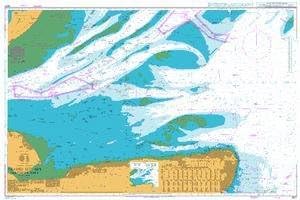
- BA Chart 1607: England a East Coast, Thames E...
0 ratings

Nº de artículo:
124546048
BA Chart 1607: England a East Coast, Thames Estuary, Southern Part
Nº de artículo:
124546048
GTQ 836
Price Details
Excluding Shipping & Custom charges ( Shipping and custom charges will be calculated on checkout )
*All items will import from Estados Unidos
0 ratings
Escribe una opinión
En stock
QTY:
Haz tu pedido ahora y recíbelo por ahí Martes, Junio 30
Secured transaction
Ubuy works hard to protect your security and privacy. Our advanced payment security system ensures confidentiality by encrypting your information during transmission using AES (Advanced Encryption Standards) and SSL (Secure Socket Layer) protocols. Your payment details are 100% secure as we do not share your payment details with third party sellers.
Our Top Logistics Partners
Admiralty standard nautical charts comply with Safety of Life at Sea (SOLAS) regulations and are ideal for professional, commercial and recreational use.
Fast
Shipping
Free
Return*
Secure Packaging
100% Original Products
PCI DSS Compliance

ISO 27001 Certified
What Stands Out
Comprehensive Coverage
This nautical chart provides extensive coverage of the England East Coast and Thames Estuary, ensuring navigators have essential information for safe and effective navigation in these busy waters.
Detailed Information
With precise details on depths, hazards, and navigational aids, this chart enhances maritime safety, enabling sailors to make informed decisions and avoid potential dangers while navigating coastal waters.
Durable Material
Printed on high-quality, water-resistant material, this chart is designed for longevity and durability, ensuring it withstands the rigors of marine environments, providing reliable guidance for seafarers over time.
Detalles de producto
| Item Weight | 1.5 lbs (680 grams) |
Who Should Buy?

-
Marine Navigators
Essential for navigators needing accurate maritime information for safe travels and navigation in the Thames Estuary.
-
Fishing Enthusiasts
Provides critical details about fishing zones and regulations, benefiting anglers looking to explore the area.
-
Shipping Companies
Valuable for shipping companies requiring reliable charts for transporting goods efficiently along the east coast.

-
Casual Boaters
Not ideal for casual boaters who may not require detailed navigation data for short leisure trips.
-
Land-based Travelers
Not suitable for those traveling overland, as the chart focuses solely on marine navigation and maritime routes.
-
Outdoor Recreational Crafters
May not meet the needs of outdoor crafters looking for comprehensive information on land trails or activities.
DESCRIPCIÓN DEL PRODUCTO
BA Chart 1607: England a East Coast, Thames Estuary, Southern Part
¿Tienes alguna consulta? Chatea con nosotros
Preguntas y respuestas de los clientes
-
Pregunta:
What is included in the BA Chart 1607?
Respuesta: BA Chart 1607 includes detailed nautical information of the East Coast of England, particularly focusing on the Thames Estuary and its southern part. This chart provides crucial information such as depth contours, navigational aids, topographic features, and important landmarks. It ensures mariners have comprehensive guidelines for safe navigation, helping you identify hazards and navigate through congested waters effectively. Ideal for maritime professionals and enthusiasts alike, the chart also assists in planning routes and understanding tidal flows, ensuring informed decision-making on your journeys. -
Pregunta:
Who is the primary user of the BA Chart 1607?
Respuesta: The primary users of BA Chart 1607 are maritime professionals, including sailors, fishermen, and professional boat operators. Additionally, it serves as a valuable resource for sailing schools and maritime training centers. By providing crucial navigational data and topographic insights, it helps users navigate the complex waters of the Thames Estuary efficiently. Whether you're planning a local fishing trip or engaging in a large-scale maritime operation, this chart is essential for ensuring safe and effective navigation in these busy waters. -
Pregunta:
Is the BA Chart 1607 suitable for recreational boating?
Respuesta: Yes, BA Chart 1607 is highly suitable for recreational boating. It offers detailed information that aids in safe navigation along the East Coast, particularly for those cruising the Thames Estuary. Recreational boaters can benefit immensely from understanding water depths, tidal patterns, and potential hazards depicted on the chart. This ensures a more enjoyable and safe boating experience, whether you're sailing with family or friends, exploring coastal scenery, or engaging in water sports activities. -
Pregunta:
How does the BA Chart 1607 differ from other nautical charts?
Respuesta: BA Chart 1607 differs from other nautical charts by its specific focus on the Thames Estuary’s southern part, providing detailed local insights. Unlike broader maritime charts, this chart features meticulously plotted depths and navigational aids tailored for busy estuarine waters. The local detailing gives mariners a clearer understanding of this complex area, helping to avoid potential hazards. Moreover, it supports extensive marine activities such as fishing, yachting, and commercial shipping, making it a unique resource for navigating these waters. -
Pregunta:
What kind of updates are available for BA Chart 1607?
Respuesta: BA Chart 1607 is regularly updated to ensure it reflects the latest navigational information. Updates may include alterations in shipping lanes, modifications to buoy placements, changes in depth conditions, and newly reported hazards. Mariners can access these updates through the official BA website or related nautical publication platforms. Keeping your chart current is essential for maintaining safety and enhancing navigation accuracy, making it crucial for serious sailors and maritime operators to stay informed about these changes. -
Pregunta:
Can the BA Chart 1607 be used for commercial purposes?
Respuesta: Absolutely, BA Chart 1607 can be used for commercial purposes, making it a vital tool for shipping companies and freight operators. It provides precise navigational data necessary for commercial vessels navigating the busy waters of the Thames Estuary. The information aids in optimizing routes, ensuring that vessels can maneuver safely through crowded shipping lanes while adhering to maritime regulations. This makes the chart an essential resource for efficient and safe maritime operations in commercial shipping. -
Pregunta:
Are there digital versions available for BA Chart 1607?
Respuesta: Yes, there are digital versions available for BA Chart 1607, which can be utilized via navigation software or electronic charting systems. Digital charts offer enhanced features such as zooming capabilities, real-time updating, and easier integration with GPS systems, providing users with an engaging and interactive navigation experience. These digital formats are especially beneficial for tech-savvy mariners or those operating large fleets, enabling streamlined access to critical navigational data at their fingertips. -
Pregunta:
What are the benefits of using the BA Chart 1607 for sailing training?
Respuesta: Using BA Chart 1607 for sailing training offers numerous benefits, such as providing students with critical navigational skills in a practical setting. Instructors can utilize the chart to teach sailors how to interpret water depths, understand tidal influences, and identify local landmarks. The chart's detailed information equips trainees with the knowledge to make informed decisions during practice voyages, ensuring they are prepared for real-world sailing experiences. This grounding in practical navigation fosters confidence and skills that are invaluable in their future boating endeavors. -
Pregunta:
Is there a physical or hardcopy version of BA Chart 1607 available?
Respuesta: Yes, BA Chart 1607 is available in a physical format for those who prefer traditional charting methods. The hardcopy version offers durability and can be used in various maritime environments without the need for digital devices. This is particularly useful during outdoor activities where electronic systems might be less reliable. Mariners often carry both digital and physical charts to ensure they have all necessary resources for safe navigation, especially in coastal areas known for rapid changes. -
Pregunta:
Where can I buy BA Chart 1607: England – East Coast, Thames Estuary, Southern Part?
Respuesta: You can buy BA Chart 1607 at Ubuy, a trusted online marketplace known for a wide range of products including nautical charts. Ubuy provides a user-friendly shopping experience, ensuring that you can easily find, compare, and purchase this essential chart. With Ubuy, you are guaranteed access to a reliable source for all your nautical chart needs, making it a convenient option for maritime professionals and enthusiasts.
UKHO Charts & Maps Editorial Review
No se encontraron reseñas editoriales
Customer Reviews & Ratings
1 valoraciones de los clientes
-
5 estrella
100%
-
4 estrella
0%
-
3 estrella
0%
-
2 estrella
0%
-
1 estrella
0%
Revisar este producto
Comparte tus ideas con otros clientes
Product Price History
Información importante
- Limitaciones: Para los productos enviados al extranjero, ten en cuenta que cualquier garantía del fabricante puede no ser válida; las opciones de servicio del fabricante pueden no estar disponibles; los manuales del producto, las instrucciones y las advertencias de seguridad pueden no estar en los idiomas del país de destino; los productos (y los materiales que los acompañan) pueden no estar diseñados de acuerdo con las normas, especificaciones y requisitos de etiquetado del país de destino; y los productos pueden no ajustarse al voltaje del país de destino y a otras normas eléctricas (lo que requiere el uso de un adaptador o convertidor, si procede). El destinatario es responsable de asegurarse de que el producto puede ser importado legalmente al país de destino. Cuando hagas un pedido a Ubuy o a sus filiales, el destinatario es el importador registrado y debe cumplir todas las leyes y normativas del país de destino.
- No todos los productos que aparecen en Ubuy están a la venta, ya que Ubuy es un motor de búsqueda a nivel mundial. Los productos están sujetos a las normas de exportación/comercio.
GTQ 836
Haz tu pedido ahora y recíbelo por ahí Martes, Junio 30
This item is not restrict in my country.(Please click on above link if this item is not restrict in your country, So our team will review and allow.)
QTY:
Secured transaction
Ubuy works hard to protect your security and privacy. Our advanced payment security system ensures confidentiality by encrypting your information during transmission using AES (Advanced Encryption Standards) and SSL (Secure Socket Layer) protocols. Your payment details are 100% secure as we do not share your payment details with third party sellers.
Our Top Logistics Partners
Fastest cross-border delivery
características y beneficios
- Compliant with SOLAS regulations for safety.
- Ideal for professional, commercial, and recreational navigation.
- Includes a range of scales for various nautical needs.
- Supplemented by mariners' routing guides in busy seaways.
- Corrected by trained cartographers with the latest notices.
- Produced by one of the leading nautical chart producers globally.